 www.geodatenkatalog.de (S1F)
Keyword
Indian Ocean
8 record(s)
Provided by
Type of resources
Topics
Keywords
Contact for the resource
-
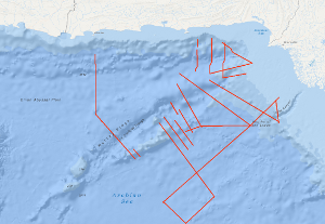
The Sonne Cruise SO122 was carried out by the Federal Institute for Geosciences and Natural Resources (BGR, Hannover) from 3rd August to 9th September 1997, in cooperation with GEOMAR (Kiel), the National Institute of Oceanography (NIO, Karachi) and the Hydrocarbon Development Institute of Pakistan (HDIP). During the joint project with R/V SONNE the Makran accretionary wedge off Pakistan should have been investigated in detail with multi-channel reflection seismics, magnetics and gravimetry. Intense fishery offshore Pakistan forced a change of the area of investigation to the south with the following objectives: investigation of the crustal structure and occurrence of the bottom simulating reflector (BSR) in the Makran accretionary wedge; investigation of the structure of the Murray Ridge System in order to reconstruct the geodynamic evolution of the eastern Indian Plate margin; determination of the origin of the crust underlying the Indus Fan and reconnaissance of the sedimentary history of the Indus Fan in order to reveal the uplift and erosion history of the Himalayas.
-
The northwestern Australian continental margin can be considered as a passive continental margin of the rifted atlantic type (Whitworth 1969; Powell 1973, 1976; Falvey 1974; Veevers 1974; Willcox 1974, 1976; Exon et al. 1975) which are usually associated with heavy accumulation of sediments (Beck et al. 1974) and are therefore of interest for hydrocarbon exploration in the longer term. The Federal Institute for Geosciences and Natural Resources (BGR, Hannover, Germany) has conducted geoscientific surveys at various continental margins of the Atlantic Ocean in the past years (Seibold 1972; Hinz et al. 1973; Seibold, Hinz 1974/1976; Seibold et al. 1975; Roeser et al. 1971) and the marine research programme of the Bureau of Mineral Resources, Geology & Geophysics (BMR, Canberra, Australia) is putting the focal point as well on the survey of the continental margins. Hence in the frame of the Australian-German contract of scientific and technical cooperation, BGR has proposed joint geoscientific surveys of the continental margins with the German research vessel VALDIVIA. The Scott-Plateau (NW-Australia) has been chosen as investigation area because BMR has carried out geophysical overview measurements previously in that region. The survey has been planned with the main focus on the geological processes at the early rift stadium and the set of problems about the "transition of oceanic to continental crust". The following regional geological units are known: the archaic-proterozoic Kimberley shield is followed by the Browse Basin - a NE striking epicontinental basin filled with mesozoic and tertiary sediments showing a thickness of up to 10 km (Powell 1976). It is presumed that the Browse Basin is delimitated by the Scott Plateau. Presumably, the Scott Plateau consists of continental crust which thins out to the north in direction to the Argo Abyssal Plain. The development of the Browse Basin is ascribed to a series of rift processes in the late paleozoic and triassic age where gas condensates have been detected at the drill hole Scott Reef 1. The contemporary configuration of the NW-Australian basins and the NW-Australian continental margin has been formed by an important middle jurassic rift phase and a subsequent drift phase. The cruises VA16-2A from 6th to the 25th of February 1977 with geophysical measurements and VA16-2B from 25th of February to 9th of March 1977 with geological sample recovery should clarify these processes. The working area of cruise VA16-2C from 11th to 23rd of March 1977 has been the Timor Trough and the Savu Sea which separate the islands Timor, Roti, Savu and Sumba from the volcanic islands of the inner Banda island arc. The crustal structure of Sumba, of the Savu Sea and of the inner Banda island arc near Flores should be investigated with seismic methods (small explosive charges fired from the research vessel VALDIVIA in the Savu Sea and intended recording units of the Flinders University on the islands Savu, Sumba and Flores) as well as with sonobuoy stations of BGR. Newer investigations (Audley Charles 1975, Chamalaun 1974) suggest that the islands of the Banda island arc (Sumba, Savu, Roti, Timor etc.) represent the northern border of the Australian continent being underlain by the crust of the Australian continent as opposed to the assumption of other investigators (e.g. Beck and Lehner 1974) who presume the northern border of the Australian continent at the Timor Trough south of the Timor island and postulate a subduction zone between the outer Banda island arc and Australia. BMR has provided 9 tons of explosives (Nitramon) with accessories for refraction seismics. The Flinders University has prepared 7 on-shore recording units and sent to Indonesia together with operating staff. BGR conducted the marine seismic work with explosive charges and off-shore recordings with sonobuoys for refraction seismic as well as reflection seismic, gravimetric and magnetic measurements.
-
SeaCause cruise SO186-2, aboard the RV Sonne, was carried out off northern Sumatra between 21st January and 24th February 2006, with mobilisation and demobilisation in Singapore and Penang, Malaysia, respectively. The geophysical survey acquired multichannel seismic data (MCS) using a 240 channel, 3 km Sercel streamer, and a tuned airgun array comprising 16 airguns with a total capacity of 50.8 litres. Bathymetry data, using the 12 kHz Simrad swath system, subseabed data using the hull mounted high resolution Parasound profiler together with gravity and magnetic data were also acquired. The main scientific objective of the survey was to investigate the southern part of the rupture zone of the 26th December 2004 9.3 magnitude earthquake, that caused the catastrophic tsunami of that date, and the rupture zone of the 8.7 magnitude earthquake of March 28th 2005. Specifically, to identify the segment boundary between the two earthquakes, as recognised by the distribution of their aftershocks. This was to be achieved by mapping the structure of the subduction zone including the dip angle of the subducted plate, the architecture of the accretionary prism and the structure of the forearc basins, particularly their strike-slip fault systems. Also to be investigated was whether there was a contribution to the 2004 tsunami from major submarine failures. During the survey a total of 5358 line kilometres of MCS data were acquired, mainly on lines oriented orthogonal to the subduction zone and extending from the ocean basin across the trench and accretionary prism to the forearc basins offshore Sumatra. The orthogonal survey lines were located on average approximately 40 km apart. The survey was planned using the bathymetry from the HMS Scott, RV Natsushima and RV Sonne cruises carried out in 2004. The morphology of the trench and sediment thickness varies from north to south. In the north the trench is poorly defined with shallow seabed dip but with sediment thickness of ~3.5 secs (TWT). The seafloor dips increase southwards, but sediment thickness decreases to ~2.5 secs (TWT) off Nias. Both the ocean basin and trench sediments are dissected by numerous normal faults, oriented subparallel to the plate boundary, with many that penetrate the oceanic crust. In the south Fracture Zones were identified. The structure of the deformation front on the seaward margin of the accretionary prism is highly variable. While the younges main thrust are predominantly landward vergent there are examples for seaward verging thrusts. The frontal fold develops in some cases already in the french while in most cases the frontal fold is at the beginning of the accretionary wedge. At some locations there are large sediment slumps on the frontal thrusts, the slope angle of the prism varies between 6 to 15 degrees, an angle that explains the large scale slumping. The width of the accretionary prism is widest in the north of the area at 140 km and narrows southwards until in the vicinity of the islands it is 40 km. In the north and central parts of the survey area the passage from the deformation front landwards into the older prism is rapid and the seabed gradients steep. The dip of the oceanic crust remains low and there is an obvious twofold increase (6-7 seconds TWT) in the sediment thickness. The basal decollement of the thrusts at the deformation front is in the lower sediment layer overlying oceanic basement. This is traced northeastward. A possible explanation for the increase in thickness of the prism is therefore considered to be the formation of a thrust duplex. Perhaps this is due to the subducted sediment thickness. In this region the prism forms a plateau and the internal pattern of the uppermost sediments shows striking similarities to the trench fill. Offshore of Simeulue Island the prism structure changes and it forms the more usually seen taper. The offscraped sediment forms a thinner section, the thrusts are more steeply dipping. The dip of the subducted plate here is greater than in the north. Three forearc basins were surveyed. In the north the western margin of the Aceh Basin lies along the West Andaman Fault. Within the main basin the sediments are internally undeformed. Farther south in the Simeulue Basin the northern and central parts there are numerous, active steeply dipping faults. In southern part of the basin there is a transpressional fault similarly to the Mentawi Fault off southern Sumatra. There are notable ‘bright spots’ in the upper section that may indicate the presence of hydrocarbon gas. There are also widespread Bottom Simulating Reflectors indication the presence of gashydrates and there may be also one double BSR. At the southern end of the surveyed area the Nias Basin may be subdivided along its length into two parts by a northnorthwest to southsoutheast trending carbonate platform development. The basin has had a varying subsidence history, in the south the subsidence was completed before the northern part started.
-
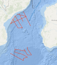
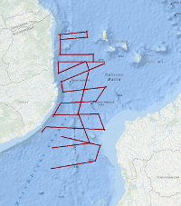
From 15th September to 26th October 2007 BGR together with the German Alfred-Wegener Institute for Polar and Marine Research (AWI), Bremerhaven, the French Institutes from Brest Institut Français de Recherche pour l'Exploitation de la Mer (IFREMER) and Institut Polaire Français Paul-Emile Victor (the French Polar Institute, IPEV) and the Portuguese Institute Laboratório de Tectonofísica e Tectónica Experimental (LATTEX) conducted a marine geophysical research cruise on the French research vessel R/V MARION DUFRESNE. The cruise BGR07 MoBaMaSis consisted of two legs MD163 off Central Mozambique and MD164 off Southern Mozambique. The main research objective was to contribute to a better understanding of the initial breakup and the early opening of the Eastern Gondwana.
-
The main goals of the project SO231-PAGE4 were an improved understanding of Gondwana break-up and to analyze timing, structures and kinematics of ancient to modern Extension along the East African continental margin. During the cruise SO231 from 20th February 2014 (Durban) to 29th March 2014 (Durban), a total of 4300 km of geophysical profiles has been acquired. The processed (migrated) profiles are available in SEG-Y Format.
-
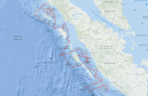
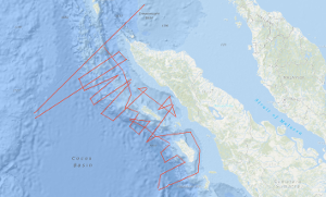
The SUMATRA cruise SO189 Leg 1, aboard the RV SONNE, was carried out off Sumatra between 3rd August and 3rd September 2006, with mobilisation in Penang, Malaysia and demobilisation in Jakarta, Indonesia, respectively. The survey was dedicated to marine geophysical measurements and acquired multichannel seismic data (MCS) using a 240 channel streamer, and a tuned airgun array comprising 16 airguns with a total capacity of 50.8 litres. Bathymetry data, using the 12 kHz Simrad swath system, sub-seabed data using the hull mounted high resolution PARASOUND profiler together with gravity (G) and magnetic (M) data were also acquired. Along two lines with a total length of ~ 390 km refraction/wide-angle seismic experiments were carried out. During the survey a total of 4,375 line kilometres of MCS, M and G data were acquired and an additional 990 km with M and G alone. The 41 MCS lines cover as close grid three fore-arc basins. Five lines extend nearly orthogonal to the subduction front and, thus, cover the whole subduction system from the adjacent oceanic plate, the trench and accretionary prism over the Outer Arc High to the forearm basins offshore Sumatra. The survey was planned using the bathymetry from the HMS SCOTT, RV NATSUSHIMA, RV MARION DUFRESNE and RV SONNE cruises carried out in 2004, 2005 and 2006. The main scientific objective of the project SUMATRA is to determine or estimate the hydrocarbon (HC) system (source rocks, HC generation, HC migration and reservoir rocks) of the Sumatra fore-arc region (mainly the fore-arc basins). Cruise SO189 Leg 1 was designed to investigate the architecture, sedimentary thickness, sedimentary evolution and subsidence history of the fore-arc basins Siberut, Nias and Simeulue off Sumatra. In the Simeulue Basin it was possible to connect the seismic lines to three industry wells and to correlate the seismic horizons to the results from the wells. The Simeulue Basin is divided into a northern and southern sub-basin. Carbonate build-ups were found in the northern sub-basin only on the very shallow shelf in the north-east. The maximum thickness was determined to be ~ 3 s TWT. In the southern sub-basin carbonate build-ups (which were already identified on some lines of the SEACAUSE project), bright spots and Bottom Simulating Reflectors (BSRs) are wide spread. The narrowest basin surveyed was the Nias Basin. As the Simeulue Basin the Nias Basin is divided into two sub-basins which are separated by a structural high. Although the basin has a maximum width of only 55 km the maximum sediment thickness exceeds 5 s TWT. The largest fore-arc basin is the Siberut Basin. It extends from the equator to ~ 5°S over 550 km and has a maximum width of 140 km between the island of Siberut and Sumatra. The maximum sediment thickness in this basin is 4.8 s TWT. The basin geometry is uniform along its axis. At the basins termination on the western side to the Outer Arc High the Mentawai Fault Zone could be traced. The geometry of this major fault changes significantly along strike. In some areas it is traceable as one single fold whereas in other areas it spreads in up to three different branches indicating splay faults originating from a main fault. In the Siberut Basin BSRs are very wide spread and very good recognizable over the Mentawai Fault Zone. Along the Mentawai Fault and along the eastern rim of the basin the seismic data show strong indications for active venting. The morphology of the Sunda Trench and its sedimentary cover varies from north to south. In the north the trench is poorly defined with shallow seabed dip but with sediment thickness of ~ 3.5 s TWT. The seafloor dips increase southwards, but sediment thickness decreases to ~ 2.5 s TWT off Nias. Both the ocean basin and trench sediments are dissected by numerous normal faults with a maximum displacement of 0.6 s TWT. Along strike the deformation front between Nias and Siberut displays several incipient folds. As offshore northern Sumatra, both landward (BGR06-228) and seaward verging folds (BGR06-227) are developed at the deformation front. For the first time landward verging folds have now been imaged in this domain of the Sunda subduction zone. In contrary to first thoughts during the expedition SO186-2 SEACAUSE, landward verging folds are not limited to the area off Aceh. Two refraction lines were acquired parallel to the subduction front at 2°30'N and 1°30'S approximately 40 - 50 km seaward of Simeulue and Siberut Island, respectively. The lines were designed to identify the segment boundaries in the subduction system as well as to detect and decipher the subducted aseismic Investigator Ridge. The gravity data set consists now of over 38,000 line km (combining the GINCO, SEACAUSE I and II and the SUMATRA data). With this it was possible to compile a map of the free-air gravity from the northern tip of Sumatra (~ 6°30'N/95°E) to Mid Java( ~8°30'S/110°E). Gravity modelling in parallel with refraction seismic data interpretation was carried along two lines during the cruise. The preliminary results show that the incoming oceanic plate is unusual thin both in the north off Simeulue (6 km) and in the south off Nias (5 km).
-
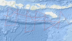
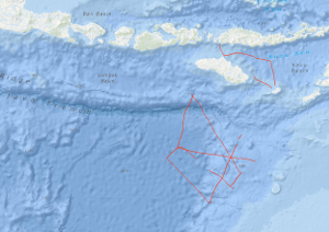
Within the framework of the research project SINDBAD (Seismic and Geoacoustic Investigations Along the Sunda-Banda Arc Transition) marine geophysical investigations have been carried out with RV SONNE from October 9th, 2006, to November 9th, 2006, off the eastern Sunda Arc and at the transition to the Banda Arc in Indonesia. The research cruise SO190 Leg 1 started in Jakarta, Indonesia and ended in Darwin, Australia. During this cruise, multichannel seismics (MCS), magnetics (M), and gravimetry (G) measurements have been carried out. Simultaneously, SIMRAD (multibeam echosounder) and PARASOUND (sediment echosounder) data have been collected using RV SONNEs onboard systems. During the expedition, a total of 4,933 km of profiles with MCS, M, and G have been acquired. Six of the 20 profiles are long overview profiles perpendicular to the deformation front and cover the entire forearc from the forearc basin across the outer arc high, the deformation front onto the oceanic lithosphere. Additional profiles have been acquired along strike in the Lombok forearc basin and in the Savu Basin. The main goal of the project SINDBAD is to investigate the relation between the variability of the lower plate and the tectonic evolution of the overriding plate (formation of an outer arc high, development of forearc basins, and accretion and erosion processes of the overriding plate). The "raw materials" – seafloor sediments, oceanic crust (at the Banda Arc also continental crust) and mantle lithosphere – are carried into the subduction system at the trench. The influence of these "raw materials" on the overriding plate is controlled by a number of factors: e.g. the convergence rate, the obliqueness of convergence and the physical and chemical properties of the lower plate (e.g. its age, its sediment-cover and –thickness, its fluid content and the composition of the crust). Forearc basins are today attracting increased attention because of their hydrocarbon potential. The forearc basins of the eastern Sunda Arc are still frontier areas which are almost unexplored. An additional goal of this project is therefore the assessment of the hydrocarbon potential of the Lombok Basin. In contrast to the Sumatra subduction zone, only a small amount of pelagic sediment is carried into the subduction system offshore East Java, Bali, Lombok, Sumbawa and Sumba. This results e.g. in a less pronounced development of the outer arc high, which is subaerial off Sumatra, but entirely below the sea surface in the eastern Sunda Arc. The Roo Rise, which is subducting off East Java, is a morphological high that lies about 1500 m higher than the Argo Abyssal Plain which is subducting further to the east. Despite of these pronounced differences, the deformation front in both areas shows similarities. While the foot of the slope shows lower dip than the upper slope, both areas are characterized by landward dipping thrust sheets. In both areas the outer arc high is characterized by active faults (the recent activity is indicated by deformed basin sediments on the outer arc high) and therefore no indications for a static backstop have been found. The accretionary character of the deformation front is clearly indicated in both areas, while subrosion in association with the subsidence of the Lombok Basin can not be excluded based on the preliminary interpretations. The trench in both areas is devoid of sediments, which indicates erosional processes caused by currents along the trench strike. However, a depocenter for these sediments could not be localized yet. While a forearc basin is not clearly developed off East Java, the Lombok forearc basin with water depths of more than 4000 m extends from off Bali to off Sumbawa. On the southern slope of the basin prograding sedimentary sequences indicate uplift, probably caused by the subducting Roo Rise or a growth of the outer arc high. Additionally, carbonate platforms on the acoustic basement indicate phases of rapid subsidence of the basin. The sediment thickness reaches a total of about 3.5 sec TWT. A few seismic "bright spots", but no bottom simulating reflectors (BSRs) have been identified in the basin. The profiles striking along the basin axis indicate paleo-depocenters in the western part of the profile, while the recent depocenter is located in the eastern part of the basin. On the northern flank of the Lombok basin, indications for submarine volcanism (recent activity is unknown) are indicated by a seamount reaching above the seafloor associated with a clear magnetic anomaly. East of the Lombok Basin the island of Sumba is located, which is regarded as a microcontinent that has been attached to the island arc during the Late Oligocene. Sumbas geographical location in front of the island arc is usually characterized by the location of a forearc basin and correlates with the seaward displacement of the deformation front (Roti Basin) at the transition from ocean/island arc subduction of the Sunda Arc to continent/island arc collision of the Banda Arc. An uplift of about 0.5 cm/a is reported for Sumba, associated with the underplating of the continental Scott Plateau. The uplift is especially evident in the MCS data. To the east of the Lombok Basin depocenter, a transition zone with deep reaching faults is observed, associated with eastward dipping sedimentary and basement structures. This transition zone is also indicated by anomalies in the magnetic and gravity data, the latter indicating isostatic undercompensation. On the western flank of Sumba, deformed sedimentary sequences indicate gravitational gliding in association with the uplift of Sumba. East of Sumba, two profiles into the Savu Basin have been acquired. Here the uplift of Sumba is indicated by the erosion of sedimentary sequences which have been deposited in the basin followed by uplift and subsequent erosion. Further indications of "inversion structures" are given by a reactivated thrust fault that in the past has served as the southern boundary of the Savu Basin und indicates recent activity by associated deformed basin sediments. The oceanic crust of the Argo Abyssal Plain and the Roo Rise is characterized by thin sediments. On a connection profile between two long profiles on the Argo Abyssal Plain a basin with about 1.4 sec TWT of sediment has been observed, that, indicated by a magnetic anomaly, can be correlated with an age jump of about 15 Ma, thereby indicating a paleo plate boundary.
-
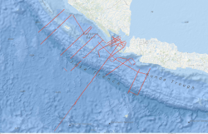
During RV SONNE cruise 137 from 21st November to 28th December 1998 Geoscientific Investigations on the active Convergence Zone between the east Eurasian and Indo-Australian Plate (GINCO I) were carried out along the Sunda Arc, off Sumatra, Java and the Sunda Strait. The studies were headed by the BGR in close cooperation with German and Indonesian research institutions. A total amount of 5,500 km of magnetic, gravity and swath bathymetric profiles were recorded of which multi-channel seismic data exceeded 4,100 km. The scientific objectives were: (1) investigation of the structure and age of the accretionary wedges, outer arc highs and fore-arc basins off Sumatra and Java with special emphasis on the evolution of the Sunda Strait and the Krakatau area (2) differences in tectonic deformation between oblique (Sumatra) versus frontal (Java) subduction (3) search for oceanic crustal splinters in the accretionary wedges (4) definition of seismic sequences, thicknesses and ages of the fore-arc basin sediments as a pre-requisite for later on hydrocarbon assessments (5) identification and regional occurrence of bottom simulating reflectors (BSR) indicating gas hydrates. From the GINCO I project there is evidence for the existence of two accretionary wedges along the Sunda Arc: wedge I is of assumed Paleogene age and wedge II of Neogene to Recent age. The first inner wedge I is composed of tectonic flakes which are correlated from SE Sumatra across the southern Sunda Strait to NW Java. This implies a very similar plate tectonic regime at the time of the flake development during the Upper Oligocene to Lower Miocene and without marked differences in plate convergence direction from Java to Sumatra. Wedge I shows backthrusting along the northern transition toward the fore-arc basin. Today, wedge I forms the outer arc high and the backstop for the younger, outer wedge II. Magnetic, gravity and seismic results show, that within both wedges, there are no indications for an oceanic crustal splinter as hitherto postulated. Both wedges are underlain by oceanic crust of the subducting Indo-Australian slab which could be correlated from the trench off Sumatra up to 135 km to the northeast and up to 65 km from the trench off Java. Since the top of the oceanic crust differs considerably in reflectivity and surface relief we distinguished two types in the seismic records. One type is characterized by strong top reflections and a smooth surface and underlies accretionary wedge II and the southwest part of the wedge I (outer arc high) off Sumatra and Java. The second type has a low reflectivity and a rougher relief and underlies the tectonic flakes of accretionary wedge I (outer arc high) between the southwestern tip of Sumatra, the SundaStrait and NW Java. The missing outer arc high off the southern entrance of the Sunda Strait is explained by Neogene transtension in combination with arc-parallel strike-slip movements. The NW-SE running, transpressional Mentawai strike-slip fault zone (MFZ) was correlated from the SE Sumatra fore-arc basin to the NW Java fore-arc basin. Off the Sunda Strait northward bending branches of the MFZ are connected with the Sumatra Fault zone (SFZ). It is speculated that the SFZ originally was attached to the Cimandiri-Pelabuhan-Ratu strike-slip faults and shifted from the volcanic arc position into the fore-arc basin area due to clockwise rotation of Sumatra with respect to Java as well as due to increasingly oblique plate convergence since the late Lower Miocene. We explain the transtension of the western Sunda Strait (Semangka graben) and the transpression with inversion of the eastern Sunda Strait, along the newly detected Krakatau Basin, by this rotation. Seismostratigraphic interpretation revealed 5 main sequences (A - E), tentatively dated as Paleogene to Recent in age. The oldest seismic sequence A of assumed Eocene to Oligocene age is bounded at the top by a major erosional unconformity that was identified on all GINCO seismic profiles. The seaward diverging seismic pattern of sequence A is interpreted as a correlative sequence to the prograding Paleogene deltaic sediments encountered by wells offshore central and northern Sumatra. This is opposed to previous interpretation which assumed seaward dipping reflector sequences of basaltic origin erupted along the former Mesozoic passive margin of Sumatra. According to constructed time structure maps, the main NW-SE running depocentres of the post-Paleogene sediments are arc-parallel off Sumatra and Java with thicknesses of 3 s (TWT) and 5 s (TWT), respectively. The main depocentres of the Semangka graben and of the Krakatau Basin of the Sunda Strait strike north-south and have infills of 2 s - 5 s (TWT). Bottom simulating reflectors (BSR) occur within the upper sequences C - D along the flanks of the fore-arc basins and along doming structures but could not be detected in basin centres. Empiric relations of heat flow values and depths of BSR were determined indicating that with increasing waterdepth and decreasing heat flow the depths of the BSR increase.